Santa Elena Canyon Trail: Big Bend’s Signature Hike
The Santa Elena Canyon Trail may be one of the most accessible hikes in Big Bend National Park, West Texas; however, that doesn’t make it any less stunning.
The canyon was formed by the Terlingua Fault line, which tore apart an otherwise impenetrable 1,500-foot wall of rock reminiscent of Game of Thrones.
The Rio Grande River flows west through the canyon, affording kayakers and rafters the opportunity to explore further than is possible on foot.
The river also acts as the official border between the United States and Mexico, as it does throughout Big Bend National Park.

Getting There
On our first of two full days in Big Bend, Kel and I drove into the park from Terlingua before sunrise.
We arrived at the Panther Junction Visitor Center at 8:30 a.m., just as it opened. There, we paid the $30 vehicle entrance fee for the park.
Next, we drove along the 30-mile Ross Maxwell Scenic Drive to the Santa Elena Canyon Trail.
The 45-minute scenic drive through the Chihuahuan Desert was spectacular, and as it was early, we had the road to ourselves.
We hoped that by driving straight to Santa Elena Canyon, we’d have Big Bend’s most popular hike to ourselves.
It was a bet that paid off, and we didn’t miss anything because the only way back from this southwestern region of the park is the Ross Maxwell Scenic Drive.

Santa Elena Canyon Trail
We arrived at the small parking lot near the Santa Elena Canyon Trail entrance around 9 a.m. Finding a spot that early wasn’t a problem, and a few basic restrooms with flush toilets are available.
While we were the only hikers I saw, several guides were unloading kayaks ahead of a tour group’s arrival.
Mid-morning is an excellent time for this hike, as the sun is high enough to illuminate the canyon entrance but not yet directly overhead.
The cliff walls are so tall they afford plenty of shade, keeping temperatures cooler. If you’re going in summer, keep this in mind, as it can get dangerously hot. We were there in October.

The Santa Elena Canyon trailhead, like all those in Big Bend National Park, has a sign in English with key information, including:
- Duration of the hike (1.4 miles round trip)
- Elevation gain (80 feet)
- Geography
- Trail safety tips (watch out for snakes and mountain lions)
- Trail rules (no pets, bicycles, or camping)

Hiking in Santa Elena Canyon
The hike into Santa Elena Canyon begins with a short walk on flat ground, parts of which are covered with a wooden boardwalk.
The Terlingua Creek feeds into the Rio Grande River, and you’ll need to cross the creek to continue on the trail, which extends along the northern (U.S.) side of the river.
We were there in mid-October, and while there’d been heavy rains the week before our arrival, enough time had passed for the water levels to go down.
The water was about ankle-deep and easily crossed by hopping on well-placed rocks.
If you arrive and the water level is too high, you can’t safely access the canyon. It’s also important to be aware of the weather in the region.
While it’s a short hike in and out, you wouldn’t want to get stranded in the Santa Elena Canyon due to a flash flood blocking your way out.

Once you’ve crossed the creek, the Santa Elena Canyon Trail features a short but rocky incline.
A sign points out that marine fossils, visible in the rock behind it, are evidence that Big Bend National Park was covered by a vast sea during the Cretaceous Period 100 million years ago.
We were on our own walking into the canyon, but on our way out, we saw parents taking a break from hauling a wheeled stroller up this section of the trail (not something I’d recommend).


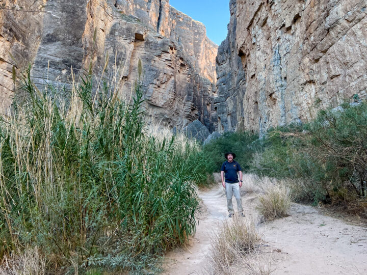
As we continued our hike into the Santa Elena Canyon, the elevation decreased until we walked on soft, sandy ground, about level with the Rio Grande River.
The sky was a beautiful blue, and a partial white moon was visible above the canyon walls.
We passed several massive boulders that must’ve fallen off the rock walls at some point a long time ago.

It only took us about 40 minutes at a casual pace to reach the endpoint of the Santa Elena Canyon Trail.
You’ll know you’ve read it when the trail comes to an abrupt end at the banks of the Rio Grande River.
Here, you can get a closer look at striations in the rock walls, especially on the Mexico side. If it’s calm, the water acts as a reflecting pool, making for some fantastic photos.
Beyond this point, your only option is to cruise further into the canyon on a kayak or raft.
As we hadn’t signed up for a tour, due in part to our limited time, we turned around and hiked out the way we came.


On our way out, we passed more hikers. At least we had the trail to ourselves for half the time!
As we ascended to the high point, we had a sweeping view of Big Bend National Park’s mountains in the distance.
More kayaks were lined up at the water’s edge, and the clientele was listening to a safety briefing on their excursion.
We were back at our car after about 75 minutes total.
Overall, I thought the Santa Elena Canyon Trail was a fun and easy way to begin our Big Bend National Park adventure.
The trail is easy enough for hikers of all ages, including kids. More experienced hikers with limited time may prefer to skip it for the park’s longer, more strenuous options.
For more info on visiting Big Bend, check out the park’s website.
The post Santa Elena Canyon Trail: Big Bend’s Signature Hike appeared first on Go Backpacking.
Categories: Uncategorized